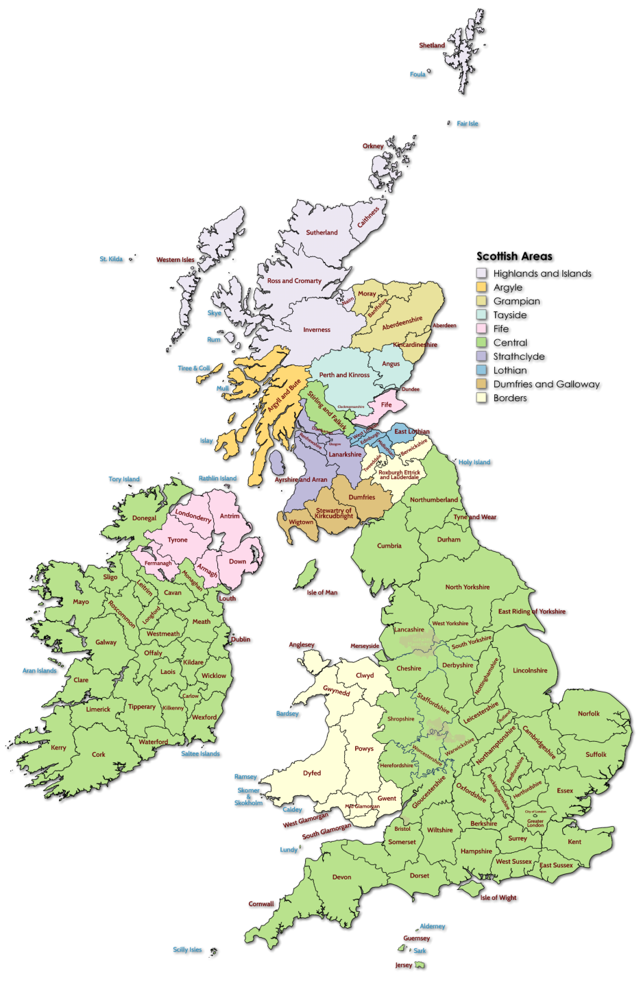



Boundaries to Counties in the United Kingdom, like most other Countries, change for many
reasons. Originally, county boundaries often followed the course of a river which seems a
very sensible way of deciding a boundary to an area. Changes to boundaries are usually
caused by political aspirations of one party or another. British people have long memories
and many refuse to recognise 'political' counties, such as metropolitan boundaries.
Sometimes smaller counties such as Rutland, return due to public pressure and others like
Shropshire, once renamed 'Salop' return to their former name.
Due to the high number and history of Inns located around the London area, the Fat
Badgers use a 'London' page which is based on the 'Greater London' Metropolitan County
for ease of use and because of the area covered by Yorkshire, the more modern
boundaries of North, South and West Yorkshire are used.
The Welsh boundaries are also ever changing, with the original boundaries shown here,
but with a lower population and therefore less inns, the Fat Badgers use the larger
counties shown on the clickable maps.
We also use the larger former regional names in Scotland that were in place between
1975 and 1996 due to the area of land covered.
We also don’t have a Fat Badger located in
Caithness which would be a long journey for
any of us to cover.



Greater Manchester
West Midlands


The Fat Badgers, in most cases, use original English boundaries as defined by Ordnance Survey. Boundary maps were first printed in 1805 and many
counties remain almost unchanged. There are many other 'areas' of the United Kingdom which are well known but are not official counties such as
The Black Country, The Potteries, and The Cotswolds. More information on these areas and former Counties.
Pub County Boundaries


















 Pubs
Pubs Open Map in New Window
 England
 Scotland
 Wales
Wales Ireland
 County Map
 About Britain
 Pubs
Pubs British Beer
 Perfect Pint
 Beer Glasses
 The Barren Years
 Real Fires
 Breweries
 Brewing
 British Food
 Recipes
 Pub Interiors
 Dog Friendly
 Pub Games
 Strange Pub Names
 Visitor Information
 Oldest Pub
 Pub Signs
 Micropubs
 Buildings
 Cathedrals
 Stately Homes
 Castles
 Listed Buildings
 Scheduled Monuments
 Oak Framing
 Architecture
 Thatching
 Waterways
 Sailing
 Shipbuilding
 Boatbuilding
  Shipping Forecast
 Britain's Coastline
 Coastal Locations
 Piers
Piers Lighthouses
 Harbours
 Beach Safety
 British Beaches
 Canals
 Rivers
 Islands
 Lakes
Lakes Waterfalls
 Historical
 Famous People
 Kings & Queens
 Kings of England
 History of Britain
 Industrial Revolution
 Act of Union
 Beaufort Scale
 British Firsts
 World Heritage Sites
 Historical Periods
 Historical Boundaries
 Tradition & Culture
 Morris Dancing
 Film & Television
 Television
 Calendar of Events
 British Sport
 Scottish Highlands
 Money
Money Dry Stone Walling
 British Wildlife
 Class System
 Geographical
 Pub Boundaries
 Facts 'n' Figures
 British Isles
 Other Areas
 Place Name Origins
 Topography
 Suggest an Inn
 Explanation of symbols
 Why Us?
 Places to Visit
 Long Distance Paths
 National Parks
 Areas of Outstanding Natural Beauty
 Coastal Locations
 Other areas of Britain
 Maps
Maps Our Favourite Locations
 Search
 Focus On...
 News
News Contact
 About Us
 Our History
 Donate